Research
Seven tenths of the Earth's surface is covered with oceans.
A majority of the remainder is uninhabitable landmass such as desert,
rain forest, and tundra.
We inhabit such a limited area on our planet that we tend to be unaware of
what occurs in the rest of the world.
Regional climate around where we live, however, is inseparable from the
complicated system of global climate.
In the last century, great progress was made in our understanding of
individual processes critical for climate formation.
At the same time, we have learned that it is awfully
difficult to disentangle those processes from the whole climate system.
A typical example is the El Niño/Southern Oscillation (ENSO) and
its impact on midlatitude climate.
Another notable case may be found in the controversies on climate change
associated with global warming.
Monitoring how the nature behaves on a global scale is essential
to understand not only the Earth's climate system as a whole but also
a tiny piece of it upon which human life depends.
Our research group focuses on two of the most important elements of the
Earth's climate: cloud and precipitation.
Over the past decades a number of satellites have been launched with various
sensors aboard that observe the distribution of clouds and rainfall across
the entire globe.
Progress in computer capability has provided us with "virtual eyes" to
look into the world such as a cloud-resolving model (CRM) and
a general circulation model (GCM).
We study cloud and precipitation climatology by means of
satellite observation and model simulation.
Climatology of Tropical Precipitation Systems
 The nature of large-scale atmospheric circulation is fundamentally different
between the Tropics and higher latitudes.
The midlatitude atmosphere, where horizontal temperature gradient is sharp
in balance with the Coriolis force, has an internal mechanism to mix warm
and cold airs over thousands of kilometers.
We often see this happen on a weather chart as a frontal system
associated with a developing low.
The tropical atmosphere lacks this mechanism due to the weak Coriolis force.
All that is found in the tropical atmosphere, you might imagine, is beautiful
clouds towering in the clear, blue sky.
Towering clouds are indeed all that is needed for the tropical
atmosphere to drive its circulation.
The nature of large-scale atmospheric circulation is fundamentally different
between the Tropics and higher latitudes.
The midlatitude atmosphere, where horizontal temperature gradient is sharp
in balance with the Coriolis force, has an internal mechanism to mix warm
and cold airs over thousands of kilometers.
We often see this happen on a weather chart as a frontal system
associated with a developing low.
The tropical atmosphere lacks this mechanism due to the weak Coriolis force.
All that is found in the tropical atmosphere, you might imagine, is beautiful
clouds towering in the clear, blue sky.
Towering clouds are indeed all that is needed for the tropical
atmosphere to drive its circulation.
An afternoon shower on a hot summer day leaves cool refreshing air
as it passes away.
It might surprise you to learn that rainshower actually "warms" the surrounding
air inside a developing convective tower.
This is due to latent heat released when water vapor condenses into
cloud droplets.
Two thirds of global rainfall falls in the Tropics,
where latent heat released from precipitating clouds is so great that it is
a major source of energy to fuel atmospheric circulation.
Our goal here is to understand tropical climate dynamics in light of the
role of precipitating cloud systems.
Follow the link below for more details on this topic.
Tropical Convection and Environmental Variability
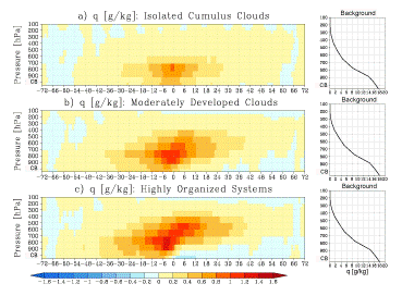 Tropical clouds develop sometimes into a vigorous, intense cloud system such as squal lines
when certain environmental conditions are met.
The condtions favorable or unfavorable for the development of intense convection include
thermodynamic factors such as moisture and static stability as well as dynamic ones like
vertical wind shear and cold air intrusion.
Convective clouds, however, are not only a passive response to the external forcing but
affect the surrounding humidity, temperature, and wind fields and can ultimately modify
the large-scale environment.
Such an interplay between tropical convection and its environment is a key ingredient of
the tropical weather/climate system but is so difficult to disentangle we don't yet
fully understand how it works.
The lack of precise knowledge of how moist convection and large-scale dynamics are related
remains a formidable obstacle to further improving our skill in
numerical weather forecast and future climate prediction.
Tropical clouds develop sometimes into a vigorous, intense cloud system such as squal lines
when certain environmental conditions are met.
The condtions favorable or unfavorable for the development of intense convection include
thermodynamic factors such as moisture and static stability as well as dynamic ones like
vertical wind shear and cold air intrusion.
Convective clouds, however, are not only a passive response to the external forcing but
affect the surrounding humidity, temperature, and wind fields and can ultimately modify
the large-scale environment.
Such an interplay between tropical convection and its environment is a key ingredient of
the tropical weather/climate system but is so difficult to disentangle we don't yet
fully understand how it works.
The lack of precise knowledge of how moist convection and large-scale dynamics are related
remains a formidable obstacle to further improving our skill in
numerical weather forecast and future climate prediction.
Satellite observations are not necessarily an optimal tool to look into a quickly varying
(over a few hours) atmosphere during the course of a cloud life cycle,
because low-Earth orbiting (LEO) satellties fly over a given point on the Earth only twice a day
at best.
An innovative aspect of the study underway is that the hourly or subdaily scale
variability is successfully, although only in statistical space, illustrated exclusively with
LEO satellite measurements alone.
How to do the trick and what it tells us about the convection-environment interaction
are outlined below (follow the link).
Tropical Air-sea Interactions
 The atmospheric is constantly exposed to heat and vapor supplies from the underlying ocean,
through which the ocean exerts a strong thermodynamic control on the atmosphere above.
At the same time, ocean surface currents are driven by winds and thus directly modulated by atmospheric dynamics.
As such, the ocean and atmosphere are interacting with each other in a somewhat complicated manner, and a small change to either atmosphere or ocean
could ultimately give rise to a drastic variability in global-scale climate.
ENSO is a notable example of tropical air-sea interaction, and the east Pacific intertropical convergence zone (ITCZ) is another.
The atmospheric is constantly exposed to heat and vapor supplies from the underlying ocean,
through which the ocean exerts a strong thermodynamic control on the atmosphere above.
At the same time, ocean surface currents are driven by winds and thus directly modulated by atmospheric dynamics.
As such, the ocean and atmosphere are interacting with each other in a somewhat complicated manner, and a small change to either atmosphere or ocean
could ultimately give rise to a drastic variability in global-scale climate.
ENSO is a notable example of tropical air-sea interaction, and the east Pacific intertropical convergence zone (ITCZ) is another.
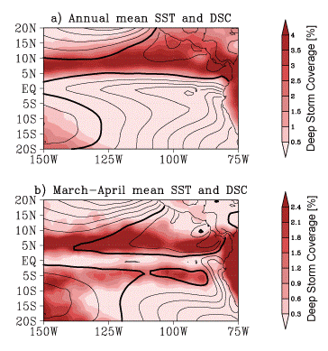
In satellte imagery the tropical east Pacific shows a distinct band of high cloudiness and warm sea surface extending east-west slightly off the equator.
This is called ITCZ.
Sea surface temperature is delineated by contour and deep convective cloudiness is shaded in the right figure.
The ITCZ is confined to the north hemisphere in the annual climatology (top panel),
although its southern counterpart emerges momentarily in March and April (bottom).
This asymmetric configuration of the ITCZ has been a long-standing mystery and,
while theories exist to explain it,
thorough observational verification of existing hypotheses with large-scale datasets has yet to be done.
Satellite data analysis was done in our recent work to look into the ocean surface heat budget in attempt to address the outstanding problems in this area.
Equatorial Waves Coupled with Convection
A phenomenon specific to tropical and subtropical climate is a pair of
rainy and dry periods that take place by turns.
Seasonal change is an obvious factor responsible for repeating
wet and dry phases.
A faster cycle with a period of a month or two is also known to dominate
tropical weather patterns,
but the origin of its periodicity is less obvious.
This intraseasonal variability has been a popular and challenging
subject in tropical meteorology for years.
 A pebble thrown into a pond makes ripples propagating away.
The atmosphere, as if it were a gigantic pond, is also filled with
invisible waves traveling around.
A wave of the atmosphere becomes visible when a disturbance of air creates
a lampshade-like cloud as occasionally observed in the downstream of mountains.
If wave-induced clouds grow deep and get organized to form a heavy storm,
the resultant thermodynamical impact on the surrounding atmosphere would be so
large that it could dynamically feed back the wave propagation.
This type of an atmospheric wave is called a convectively-coupled wave
or moist wave.
Of particular importance are convectively-coupled equatorial waves
that extend from the Indian ocean all the way to the Pacific ocean,
oscillating at periods as slow as a month or two.
Such synoptic- to planetary-scale modes are believed to be a key
for explaining tropical intraseasonal variability.
A pebble thrown into a pond makes ripples propagating away.
The atmosphere, as if it were a gigantic pond, is also filled with
invisible waves traveling around.
A wave of the atmosphere becomes visible when a disturbance of air creates
a lampshade-like cloud as occasionally observed in the downstream of mountains.
If wave-induced clouds grow deep and get organized to form a heavy storm,
the resultant thermodynamical impact on the surrounding atmosphere would be so
large that it could dynamically feed back the wave propagation.
This type of an atmospheric wave is called a convectively-coupled wave
or moist wave.
Of particular importance are convectively-coupled equatorial waves
that extend from the Indian ocean all the way to the Pacific ocean,
oscillating at periods as slow as a month or two.
Such synoptic- to planetary-scale modes are believed to be a key
for explaining tropical intraseasonal variability.
Follow the link below for more details on this topic.
Satellite Data Simulator Unit
 Modern technologies gave birth to flying "artists" who paint
cloud and rainfall on a gigantic canvas known as satellite imagery.
The artists dedicate themselves to faithfully reproduce what they saw,
but we cannot figure out what they painted without proper interpretation.
A fair amount of work is required to transform a sequence of downlinked
digital signals into a map of rainfall patterns as appears in weather forecast.
Such a software to process satellite data is called a
retrieval algorithm.
Modern technologies gave birth to flying "artists" who paint
cloud and rainfall on a gigantic canvas known as satellite imagery.
The artists dedicate themselves to faithfully reproduce what they saw,
but we cannot figure out what they painted without proper interpretation.
A fair amount of work is required to transform a sequence of downlinked
digital signals into a map of rainfall patterns as appears in weather forecast.
Such a software to process satellite data is called a
retrieval algorithm.
A crucial component of remote-sensing retrieval algorithms is radiative
transfer simulation to synthesize satellite measurements.
Radiative transfer simulation deals with the interaction of radiation with
the Earth surface and atmospheric constituents, which involves a variety of
physical processes such as the scattering and absorption of radiation.
Computational schemes to solve radiative transfer problems are individually
optimized to different kinds of sensors for practical reasons.
For example, a radiative transfer code desinged for microwave frequencies
is generally not interchangeable with a visible/infrared simulation program.
Recent Earth-observing satellites carrying multiple sensors, however, have
led to increasing demands for a radiative transfer code applicable uniformly
to different types of sensors.
The Satellite Data Simulator Unit (SDSU) was developed for simulating
data from space-borne microwave radiometers, radars, and visible/infrared
imagers.
Potential application of the SDSU package is not limited to retrieval
algorithm development but also includes cloud-resolving models (CRMs).
It would help test and improve CRM performance to assess simulated
measurements of various satellite sensors
in comparison with actual observations.
Follow the link below for more information and download.
Evaluation of Cloud Models by Satellite Measurements
What would you answer if a child asks you how a cloud is made?
If you have a bit of knowledge on meteorology, you would somehow
succeed in satisfying the child.
But what if the child asks you why the cloud looks like a puppy?
You would find the second question by far more difficult to answer.
Even the most advanced cloud models running on cutting-edge super computers
are still struggling to reproduce realistic clouds just as they are,
let alone in the ways as kids imagine.
 The difficulty in simulating realistic clouds might be partially due to their
chaotic nature.
The limited capability of simulating clouds arises also
from technical problems inherent in cloud-resolving models.
Some of such problems are merely constrained by practical requirements:
for example, the atmosphere has to be divided by a coarse grid in
cloud models so that computations fit the size of cpu and memory available.
There are other problems, such as "parameterized" physical processes
prescribed somewhat arbitrarily, that can be improved if we know how.
A careful analysis of real clouds may give us a clue to find out the way
how the model physics should be refined.
The difficulty in simulating realistic clouds might be partially due to their
chaotic nature.
The limited capability of simulating clouds arises also
from technical problems inherent in cloud-resolving models.
Some of such problems are merely constrained by practical requirements:
for example, the atmosphere has to be divided by a coarse grid in
cloud models so that computations fit the size of cpu and memory available.
There are other problems, such as "parameterized" physical processes
prescribed somewhat arbitrarily, that can be improved if we know how.
A careful analysis of real clouds may give us a clue to find out the way
how the model physics should be refined.
The Center for Climate System Research (CCSR) at the University of Tokyo and
the Japan Agency for Marine-Earth Science and Technology (JAMSTEC) are
in tandem developing a global cloud-resolving model called
the Nonhydrostatic ICosahedral Atmospheric Model (NICAM).
The NICAM is capable of simulating individual clouds as well as
planetary-scale dynamics at the same time.
Working together with NICAM developers,
we have started a project to analyze NICAM simulations jointly with
spaceborne radar measurements.
Detailed observations of the cloud and precipitation structure are provided
by the Tropical Rainfall Measuring Mission (TRMM) Precipitation Radar (PR) and
CloudSat Cloud Profiling Radar (CPR).
Results from a preliminary analysis applied to the NICAM MJO experiment is
available from the link below.
Algorithm Development for Global Precipitation Measurement (GPM)
Coming soon. (Who said "soon" never comes?)